Navigation Rules | ATONS
The Navigation Rules for vessels establish actions for boaters to take to avoid a collision. The Navigation Rules are published by the U. S. Government Printing Office, and are available in any boating supply store. Every boat owner should have a copy, but it is mandatory that a copy be kept aboard all vessels over 12 meters (39.4 feet) in length.
Knowing a few simple rules will help you stay safe on the water. Since there are so many different types of boats, boating activities and styles of boating, it is important to know what to expect when you come upon another vessel and what your obligations are. The term "vessel" includes anything that floats on the water that is used, or is capable of being used as a means of transportation on water. Therefore practically everything you encounter on the water is considered a vessel and as such, must know, understand and abide by the Navigation Rules. The Navigation Rules cover steering rules akin to rules of the road, sound signaling equipment and requirements, and a section on navigation lights.
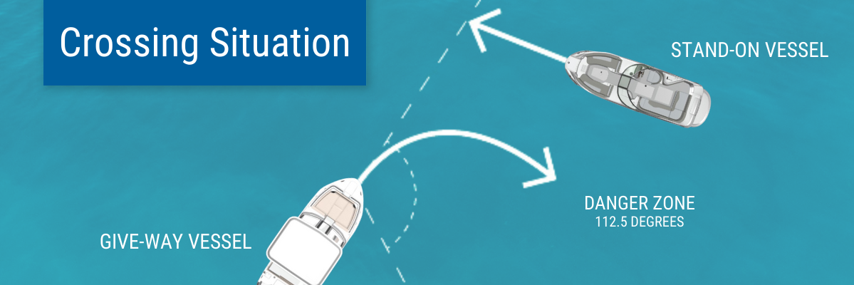
Proper and safe on-water navigation has many facets. Entire books and courses are offered on this very topic. Only the basics are presented here. To learn more take the free, online BoatUS Boating Safety Course. The most basic scenario when meeting another boat is usually going to be one of the following: a crossing situation, a head-on situation, or an overtaking situation.
Crossing Situation

Meeting Head-On

Overtaking Situation

The responsibilities of a boat operator are many. Basic knowledge is just that. You should strive to know all the requirements expected of boaters, including what to do when you encounter commercial vessels, vessels engages in fishing and diving and law enforcement personnel. At an absolute minimum, you should always have a proper lookout, operate at a safe speed and yield or give-way to another vessel when in doubt and to always avoid a collision, even if that means breaking a Navigation Rule to save lives and property damage.
Aids to Navigation
Unlike the roads and highways that we drive on, the waterways we go boating on do not have road signs that tell us our location, the route or distance to a destination, or of hazards along the way. Instead, the waterways have Aids To Navigation (or ATONs), which are all of those man-made objects used by mariners to determine position or a safe course. These marks are also indicated on your chart.
The term "aids to navigation" includes buoys, day beacons, lights, lightships, lighthouses, radio beacons, fog signals, marks and other devices used to provide "street" signs on the water. Aids to navigation include all the visible, audible and electronic symbols that are established by government and private authorities for piloting purposes. To help you understand what these mean, the basics are presented here.
Port Side Odd Numbered Aids
These Nav Aids are numbered with odd numbers, are green in color, and may be lighted (will have a green light). Port side marks are located on the left side of the waterway as you travel upstream, and the buoy numbers will increase as you head upstream. (Chart depictions are shown next to the marks) Port-Side Buoys have a cylindrical above-water appearance, like a can or drum floating on its axis. Commonly referred to as "CAN" buoys. Beacons - Port side beacons have square marks attached to them, with two shades of color and a reflective border.

Starboard Side Even Numbered Aids
Starboard aids are red in color, evenly numbered, and will be on your right side as you travel upstream. Buoy numbers increase as you head upstream, and may have a red light. Starboard-side Buoys have an above-water appearance like that of a cylinder topped with a cone, pointed end up. The cone may come to a point or be slightly rounded and are commonly referred to as "NUN" buoys. Starboard-side Beacons have triangular marks attached to them, with two shades of color and a reflective border.

Regulatory Marks and Other Aids
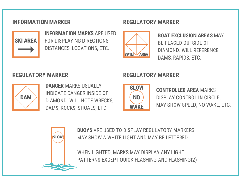
Regulatory marks are designed to assist boaters by informing them of special restrictions or dangers that they are approaching. Regulatory marks are white "can" buoys that have an orange shape on them. The mark will give either a warning or instructions on how to proceed. The shape determines what type of mark it is.
- A square or rectangular shape is used for conveying instructions.
- An open diamond shape signifies danger.
- A diamond with a cross in it signifies an exclusion area that you may not enter.
- A circle indicates an upcoming operating restriction, such as a speed limit.


