
Weather To Go
Foundation Findings #49 - July 2010
For this edition of Foundation Findings, we examined weather delivery options that coastal and inland boaters can use while out on the water.
Sure, marine weather over a VHF radio is the tried and true method for knowing whether that dark cloud approaching is going to ruin your day but what if... you could see a radar image of the approaching storm and know that you only needed to travel a few miles south to get out of the trajectory of the storm?
At your fingertips is marine weather information that just a few years ago was only accessible on land. New technologies are being developed daily that can deliver weather to boaters out on the water. In this test, the Foundation looked at mobile phone based weather products, satellite weather services and weather accessible on the internet for inland and coastal boaters.
VHF Satisfactory, But...
In preparing for this Foundation Findings we polled staff about their feelings on VHF marine weather and what information they wanted while boating:
- "During my pre-departure check list I turn on VHF channel 2 to get the local marine weather and then continue prepping the engine, opening valves, identifying enough life jackets, etc. After the computer generated voice reads through a half dozen zones, they get to mine. If I am busy then I miss it and have to go through the cycle again. Give me the information right away so I can digest it."
- "On hot summer days I know that there is a high possibility of thunderstorms. It's like that every summer day. If I can see a radar loop I have a better idea of the direction and speed of an approaching storm."
- "As a racing sailor there is only so much you can get from VHF marine weather. I need wind and tide/current information. Before I leave the house, I get a general idea about the forecast from online resources. But if I had that information available to me throughout the course of a day we would be a step ahead of our competitors."
Whether you are fishing, tubing, or sailing getting accurate, timely weather information is critical for making it a fun safe day while out on the water.
Test Background
We tested more than two dozen weather products on the market - everything from cellular phone text messaging to Sirius satellite weather on a chart plotter. For the purpose of this test we did not examine offshore communication methods such as satellite phones, Inmarsat or weather fax products but focused on weather products available to inshore and near coastal boaters at nominal prices.
Given that "download" time could vary tremendously based numerous factors we focused our review on the information that each product delivered. We scored each product on its ability to deliver local land-based weather information (current conditions, temperature, humidity, wind strength, barometer, and visibility), hazardous weather warning, radar image/loop, weather forecast, marine forecast and buoy weather reports.

It is worth noting that each of the products we tested was delivered via a hardware and software platform (text message, Android App, mobile web, Iphone App, Raymarine Chartplotter, etc) and the service providers (multiple cellular and satellite companies). Some products could be available on multiple platforms and providers and some are limited to one platform and provider. Given the evolving nature of cellular phone apps be sure to check current product list on your phone and online to be sure that it is available.
This test was performed in March/April 2010.
Flip Phone Options
Don't go out and buy that smart-phone just yet. For basic cell phone users there are several options available to you. Sure it might not be shown on the biggest screen, it might have advertising, and you might have to scroll a lot but there is a good chance that it will be free.
Text Alerts & On-Demand Messaging
Both Weather.com and Weatherusa.net allow you to sign up for weather alerts sent to your phone as text messages. Both offer free options and weatherusa.net offers a fee based premium version - standard text messaging rates apply. You set the frequency and the type of alert you want to receive. Here are the subscription only options weather.com offers: Severe Weather, Pollen Alert, Rain Alert, Extreme Heat, Cold and Ice Alerts.
Tip: Sign up for subscription services online so you can find all the options available.
Weather.com also offers On-Demand Messaging for boaters out on the water who need immediate weather information. Custom text messages are sent to your phone depending on the type of alert you select. Get On-Demand Weather Forecast for your location by texting your zip code or city and 2 letter state abbreviation to 42278 or 78676. If you want Current Conditions (CURR) or Daily Surf and Sea Conditions (SEA) add these codes to the beginning of the text message.
Mobile Web
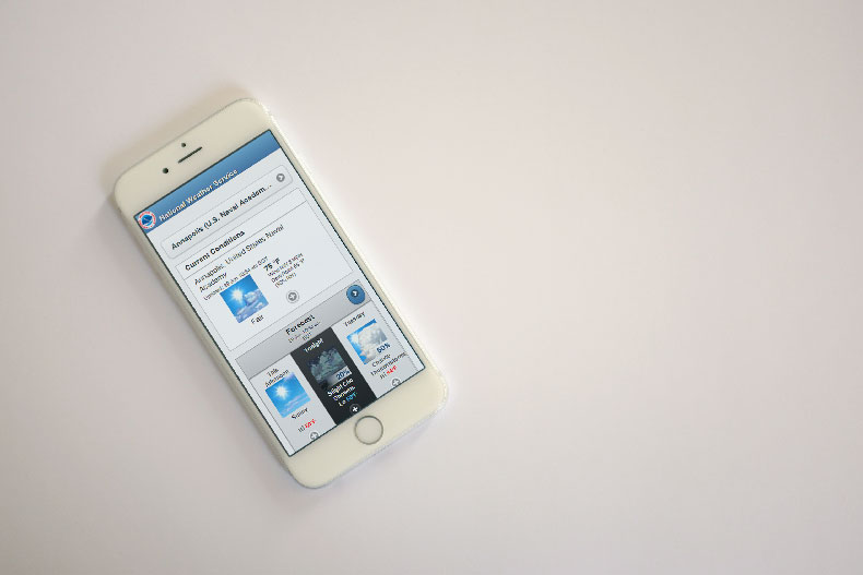
Online Resources: mobile.weather.gov
If your phone is equipped with mobile web browsing you can access free weather information. The sites listed above have current weather, forecast and radar. These services might not be the most visually appealing but they get the job done. In fact, we found that the Mobile Weather Underground had the easiest layout to read on a small screen. The NOAA mobile website has features and information that many of the paid apps lack. In addition to land-based weather reports you can also "search" for marine forecast and get buoy station reports. You might have to root through several pages and "click" several times but it is available.

Tip: Eliminate searching for current buoy weather by knowing local NOAA Station IDs.
Subscription Weather Applications
Also available from many phone providers are subscription plans for weather services. These are add-on services to your phone plan and are provided by many third party companies such as: My-Cast, Pilot My-Cast, Fishing My-Cast, WeatherBug, The Weather Channel, Intellicast, and AccuWeather. Current prices range from $2.99 to $9.99 a month.
Tip: These add-on weather services are provider and phone model dependent so the best way to find out if you have access is to log-in online to you mobile phone account and see if it is listed as an option.
Dail-In Services
NOAA has several free dial-in services for boaters to get marine weather and tidal-current information. These products are distributed by various offices within NOAA so there is overlap in the information. You have to know the geographic identifiers for your local marine weather.
Tip: Most dial-in services have extensive phone trees. Try the process out first to pick the one with the least steps for you.
- The National Weather Service has offices throughout the country with local phone numbers that have recorded marine and local forecast as found on NOAA Weather radio.
- The National Data Buoy Center offers a nation Dial-A-Buoy phone number with recorded marine forecasts. Call 888-701-8992.
- The PORTS program provides real-time tides and current data for 18 regions throughout the U.S. Visit the website for your local phone number.
Smartphone Weather Applications
Software applications (apps) downloaded to your smart-phone are a fairly new development. We found most of them had better graphics and displayed weather detail in a more appealing way than mobile web pages. There are lots of products on the market but depending on your phone platform and service provider you might be limited to just a few options. The good news is that the most prominent weather providers on the internet have both free and fee based applications across several phone platforms. The best search results for weather Smartphone apps will be found by searching the web store or market on your phone. We did a lot of searching on the web but many of the developers are small and do not have the web presence that will generate enough hits to put them high in the web rankings.
Recommendation: Try out the free options from several providers such as The Weather Channel, Accuweather and our free option best-pick WeatherBug on your phone.
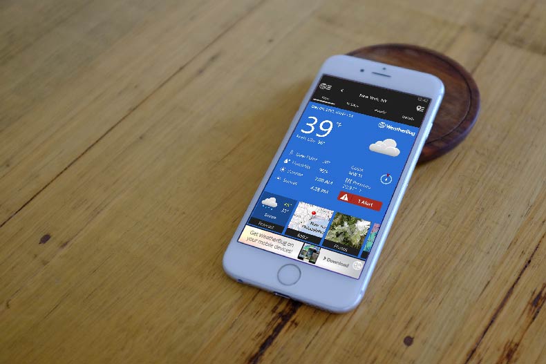
The Weatherbug app displayed on an iPhone
There are few Marine Weather Smartphone apps on the market. The ones that you can find are predominantly on the iPhone platform and range in price from $2.99 to $5.99. Three images of smart phones display different points of view.Many Marine Weather apps just take the NOAA weather data and reformat it to display on a smartphone screen. Once you have selected your weather area many of the apps will remember this and when relaunched they will provide the region's weather as the default.
Tip: Get a free weather app to cover your daily needs and select a marine weather app just to focus on marine forecasts and buoy reports.
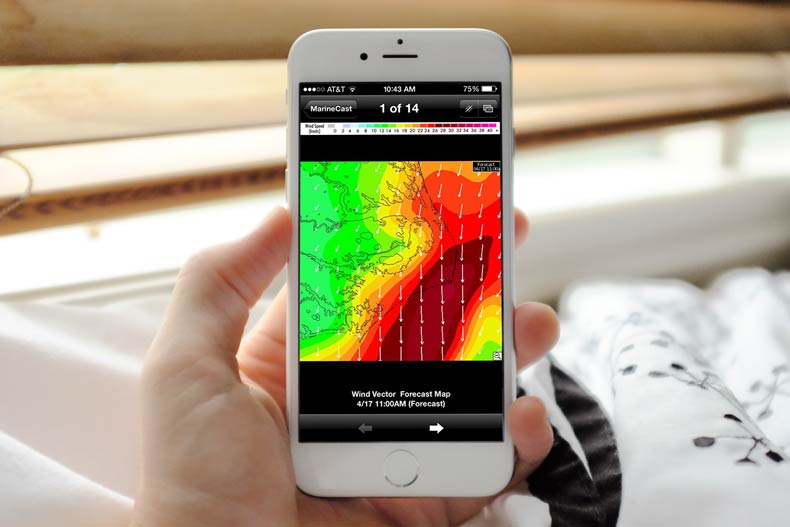
The MarineCast app displayed on an iPhone
MarineCast ($3.99) on the iPhone platform provided a graphical map display of marine weather that we found incredibly useful. For a given area, select a dataset such as radar or tide level and scroll through forecast maps in one-hour increments to see the predicted change.
Mobile Mariner ($4.99/mo) on the Blackberry RIM platform can display historic buoy data and marine weather forecast. Historic buoy data such as wind, water temperature, and tide level are shown as line graphs to identify trends. Programming several NOAA stations as default locations can help present a regional weather outlook with specific data.
Satellite Weather
An option that has been available for many boaters over the past few years is Satellite weather overlaid on a marine chart plotter. XM and Sirius, though one company now, still offer different product options that only display on certain brands of chart plotters. For example, Raymarine chart plotter owners can only install and subscribe to Sirius Satellite Weather products at this time and Garmin chart plotters only accept XM WX Weather equipment and subscription.
It is important to note that your hardware selection could limit weather subscription options. In our case, we tested the Bushnell Onix 400; a handheld GPS that though intended for inland use, had potential for near coastal use. We found out that it was only capable of displaying the XM Weather "Skywatch" subscription ($9.95/month + activation fee) which seemed to limit the radar image to within 10 miles of the coast.

As you would expect, the most expensive product we reviewed - the Raymarine SR50 Sirius Receiver installed with the C120 Multifunction Navigation Display (MSRP $3,135.00) provided for some of the best weather detail. Big buttons and a big screen made navigation through the various features easy. Weather warning and local marine weather forecast displays in text boxes. Move the cursor over a NOAA weather buoy to get current weather data. Radar image chart overlay along with other data fields such as lightning overlay can be turned on and off. This became a necessity when a large weather system moved over our area and we could not see the chart details that would be needed for navigation. The Sirius receiver used in conjunction with fishfinder sounder and radar radome truly make this a multifunction marine electronic.
As the data provider for XM Weather, WxWorx provides yet another way to access weather. A computer laptop or other marine display connected to portable receiver and any number of XM antennas will get you full XM weather for as little as $918 for the hardware. Three monthly subscription options are available from $29.99 to $49.99 for boaters and an online trial version is available to test the features.
Internet Resources
Online weather resources are extensive. Having Internet access onboard is an unnecessary luxury for most near-coastal and inland boaters.
More problematic is the connection to the Internet. Whether you are tethered to a cell phone modem, hotspot or satellite phone - online web resources need to load quickly. Much of the time this means websites that are not graphics intensive. To test load time download a Java program to mimic load speeds of various weather websites that you use at home.
Ocens Weathernet is a standalone program that when connected to the Internet will download selected weather products for a yearly subscription fee ($99) and a pay-per-product fee ranging from $0.30 to $5. We found that this pay-to-play pricing structure could potentially be less expensive for satellite phone users when compared to Internet searches for weather details due to the slow connection speed.
On Weather Underground mobile site information for a given location is shown in one screen which makes it easy to find. Scroll down on the page and find the information in the picture above.
Foundation Picks and Product Chart
When reviewing different weather products it became apparent to us that variables such as connection speed, platform type, and screen size could affect how we judged the product. Without these variables, we were able to identify the weather data that was most important to boaters. We judged each product based on the data presented across several categories.
- On Land Weather Features: One point for each data field - Current Conditions, Temperature, Humidity, Wind Speed, Barometer and Visibility. (0-6)
- Are hazardous weather announcements displayed? (Yes/No)
- Is there a radar loop or image? (Yes/No)
- Always wear a properly fitted PFD
- Does the product include an on land weather forecast? (Yes/No)
- Is a marine weather forecast available? (Yes/No)
- Does the product include present current buoy weather data? (Yes/No)
Foundation Picks 7/10/2010
Best Free Flip Phone Option: NOAA’s mobile.weather.gov
Best iPhone App: MarineCast
Best Blackberry App: Mobile Mariner
Best Free App: WeatherBug
Satellite Weather: XM WX Weather
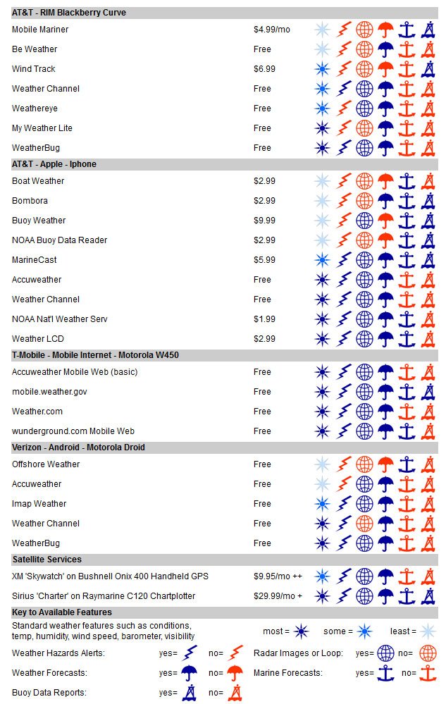
++ $14.00 activation fee
+ $25.00 activation fee